
Aerial image of clear-cut mangrove forest in
Cikmas Block, Legon Lele Resort, STPN II Karimunjawa, Karimunjawa National
Park, for intensive shrimp ponds construction (document of Centre of
Karimunjawa National Park)
MANGROVE – SHRIMP PONDS –
KARIMUNJAWA NATIONAL PARK
Isai Yusidarta, ST.,
M.Sc., Sutris Haryanta, S.H., Yusuf Syaifuddin S.Bio., M.A., Nugroho Dri
Atmojo, SP., Mulyadi dan Agung Setiyadi - Office of Karimunjawa National Park
Translator: Anninda Nurul
Islami – Directorate of Settlement of Environmental Dispute, Ministry of Environment and Forestry
Karimunjawa Island consists of 27 small islands, each island is less than 2.000 km2.
Theoretically, there are some characteristics of small islands in Karimunjawa
Island, they are 1). The small islands are situated far from the mainland; 2).
The existence of small islands is influenced by coral reef, mangrove forest,
and seagrass as the most common ecosystem in the islands; 3). The small islands
are vulnerable to environmental changes lead by human activities or natural
disaster; and 4). Lack of raw water resources became another characteristic of
the small islands since the islands do not have groundwater basin and food
plantation.
Suryati and friends
(2009) had done a research about the changes of mangrove forest area in Pulau
Kemujan National Park Karimunjawa. This was related to the existance of small
island influenced by mangrove ecosystem in Karimunjawa Island. In her research,
Suyarti and friends (2009) stated that in 1991 the outspread of mangrove forest
in Kemujan Island was 2.815 hectare and it increased approximately 0,02
hectare/year until 2001. Up until 2009, mangrove forest in Kemujan Island was
recorded about 4.052 hectare. This showed that mangrove forest area grew about
0,14 hectare/year from 2001.
The meaning of numbers above was to show that
there was possibility of expanding the area of mangrove forest in Kemujang
Island. Developing new land would be a good potential, as known that mangrove
is a sediment trap that can deposit dissolved material in water. In the future,
the land around mangrove forest enlarge gradually, particularly Kemujan Island.
Related to a reborn of
vannamei shrimp ponds, is it necessary to outlaw the shrimp culture in
Karimunjawa? Does mangrove ecosystem in Subdistrict Karimunjawa will only
function as a conservation area? We need to look back to period 1 of shrimp
pond and the comparison to other ponds in other areas.
Mangrove profile in
Kemujan and Karimunjawa
Mangrove
profile in Kemujan and Karimunjawa in 2009 can be seen in image 1 that showed
the density class of mangrove forest in Karimunjawa in 2009. From this picture,
we can estimate:
First. Kemujan Island and
Karimunjawa have a low-density mangrove ecosystem, except in the strait that
set appart Kemujan Island and Karimunjawa.
Mangrove ecosystem in the two biggest lands in
Karimunjawa were not influenced by the flow of raw water from river regularly.
The mangrove ecosystem in this place absorbed higher water salinity than other
mangroves. It took a long time adjusting to higher salinity and direct sea
wave. Morphologically, this mangrove can be seen to grow and develop normally.
It did not look like a clump of mangrove. This appeared differently from
mangrove ecosystem growing in Thousand Island National Park.
Thousand Island National
Park (include small island without raw water flowing in), developed a
close-clump plantation method to form mangrove ecosystem as protection to its
coast against abrasion. A clump consisted of 10 – 20 mangrove with less than 1
meter gap for each tree. From this technique, Rhizophora grew well, but small.
Image 1. Map of mangrove
density in 2009 (Sugiarto, 2009)
Note:
Kemujan Island and
Karimunjawa: The flow of raw water usually happened in rainy season. The raw
water came from rain falling directly to the ground or the rush of water from
lowland rain forest in both islands, moreover those islands do not have
groundwater basin.

Image 2. Mangrove condition around Rabbit and carol housed in Cikmas. Red
line marks the edge of previous ponds of period 1.
Area
in front of the red line towards the sea shows condition of high-density and
very high-density of mangrove trees that have the same height. The image above
looks like green carpet covering the shore. It explains that most mangrove
trees stand in front of shore providing numerous roles, such as 1). Mangrove trees help prevent
abrasion by protecting shorelines from damaging waves; 2). Mangrove trees trap sediments that can help
expanding mangrove forest area; 3). As a buffer zone between sea and ponds, mangrove
trees protect ponds that can be damaged by sea wave.
Third. Mangrove ecosystem in
Kemujan Island and Karimunjawa, especially in the center and the land, were
categorized as average, sparse, and very sparse mangrove population;
This condition was
assumed to be occured as a former shrimp ponds impact in periode 1 around 1990.
Restoration for this area had been done naturally in a very long time, but the
destruction efects of managing giant tiger prawn ponds traditionally were still
being faced now in 2018. Image 3 displays satelite image taken from Google
Earth used by marine traffic site, traces complete old shrimp ponds and old
shrimp ponds that mostly covered by mangroves vegetation. Natural restoration
on mangrove cannot fully recover the impact of shrimp ponds in period 1.
Secondary succession,
happened in the center up to the mainland, did not determine the thickness of
mangroves. Secondary succession mostly occured at the rear towards the
mainland. Secondary succession was formed when mangrove reached its climax
state, that was when layer of soil did not get enough water as usual, so that
mangroves tree in that area died. As the result, the soil was covered by grass.
It became solid land at the end. The sign of the beginning of secondary
succession can be seen from a mangrove trek in Kemujan. The grass was
widespread amid mangrove tree located close to the sea. You had to pass through
the ticket box then walk around 200 metres toward the sea then turn left. The
grass around there did not grow normally or was infertile.

Image 3. In this image, shrimp ponds are
located in the east of Rabbit and carol
housein Cikmas Karimunjawa. It shows the density of mangrove trees visually
were average, rare, and very rare.
The comparison to Pantura
Central Jawa
Let us examine the
comparison of shrimp ponds in Kaliwungu Beach in Kendal, Gojoyo Beach in Demak,
Kartini Beach in Jepara, and Sluke Beach in Rembang. Pay close attention to
images below.
Satellite image 4 and 5 are the appearance of
shrimp ponds in Kaliwung Beach in Kendal and Gojoyo Beach in Demak. At the
front area of shrimp ponds in both beaches, mangrove trees are empty (there are
not mangrove trees at all). Parts of pond embankment can be seen facing
directly to the sea. This condition cause some of the parts of ponds losing its
embankment, then finally erasing the ponds completely.
There were surely mangrove
trees in both locations, but the trees were gather in small spots spreading
over an area and very sparse population. Whereas, mangrove trees worked better
in a dense population with closesness between the trees and had particular
thickness to be a good buffer between ponds and the sea. Both ponds in Kaliwungu
Beach and in Gojoyo Beach, were situated far from neighborhood.

Image
4. Shrimp ponds in North Kaliwungu sea shore, Kendal Regency


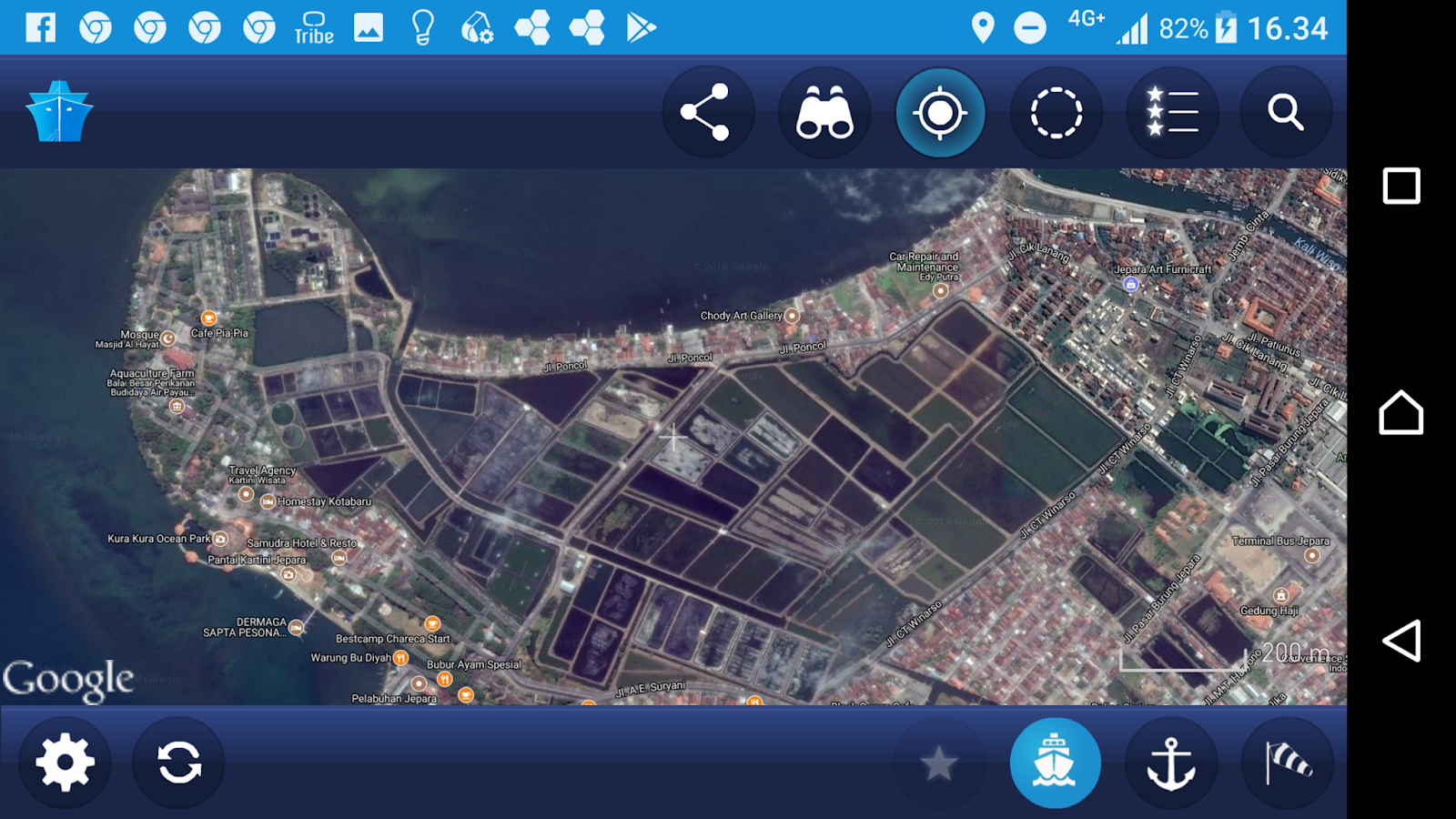
Image 7. Vannamei shrimp ponds in
Central Office of Brackishwater Aquaculture (COBA), Jepara Regency.
In the image 6 and 7, shrimp ponds are located
near densely populated neighbourhood, even packed with industrial activities as
there is a harbour, Tanjung Bonang in Sluke and COBA in the center of Jepara
City. Ponds in COBA Jepara had been surrounded by densely populated
neighbourhood and various industrial activities that produced any kind of
waste, such as household waste, small and middle industries waste, organic
waste from timber business (wood carving), and many more. In Sluke Beach and
COBA Jepara, shrimp ponds had not had mangrove ecosystem any more. For COBA
Jepara’s ponds, sea water inlet came from a waterway.
In Sluke Beach, the north, west, and east part
of shrimp ponds were connected to the sea. Meanwhile, the south part had been
surrounded by household activities, fish processing industries, and coal
transporting activities in Tanjung Bonang Harbour for the necessity of electric
steam power plant in Rembang.
In conclusion, both
shrimp ponds in Sluke, Rembang and COBA Jepara did not have mangrove ecosystem.
This became a distinctive feature of north beach of Central Java before shrimp
ponds existed.
Conditions of Shrimp Pond Business in Compared Areas
Based
on satelite images observation and data from many sources, shrimp ponds
location of four compared ares can be explained in Table 1.
Table 1. Comparison of shrimp pond
conditions in Kaliwungu, Gojoyo, Sluke, dan COBA Jepara
|
No
|
Objects
|
Locations
|
|||
|
Kaliwungu
|
Gojoyo
|
Sluke
|
COBA
|
||
|
1
|
2
|
3
|
4
|
5
|
6
|
|
1.
|
Types of ponds
|
Traditional
|
Traditional
|
Intensive
|
Intensive
|
|
2.
|
Cultivated Biota
|
Vanname and Milkfish
|
Vanname and Milkfish
|
Vanname
|
Vanname
|
|
3.
|
Owner
|
Investor‑1
|
Investor1
|
Investor1
|
Investor2
|
|
4.
|
Management
|
Local Comunities3
|
Local Comunities33
|
Local Comunities33
|
Investor2
|
|
5.
|
Authorization
|
RFBB4
|
RFBB 4
|
RFBB 4
|
RFBB 5
|
|
6.
|
Present Risk
|
Abrasion
|
Abrasion
|
Abrasion and indusrty waste
|
Household waste
|
|
7.
|
Future Risk
|
Indusrty waste
|
Agricuture waste
|
Saturated land
|
Investment load
|
|
8.
|
Front part of the ponds6
|
Normally working
|
Normally working
|
Normally working
|
-
|
|
8.
|
Rear part of the ponds7
|
Lack of proper care
|
Normally working
|
Abandon
|
Normally working
|
|
9.
|
Tenur changing
|
Factories
(KIR)8
|
-
|
Factories
|
Residence & household industries
|
|
10.
|
Investment condition
|
Working
|
Working
|
Collapse
|
Working
|
Note:
1 : personal investment and fund
2 : government institution on aquaculture
education and training funded by state budget
3 : local communities
4 : permition given to person who run small
fish cultivation
5 : institutional permit except for Fishery
Business License
6 : ponds located in seashore
7 : ponds located near land
8 : Kendal Industries Region (KIR)
Based on table 1, shrimp ponds in Sluke Beach
started to fail and the investors had left them alone. The investors were RFBB
holder in accordance with the Regulation of the Minister of Marine Affair and
Fisheries Number 49/Permen-KP/2014 concerning Fish Cultivation Business. This
condition was driven by saturated water as the means of shrimp pond and the
soil around the ponds. Saturated water here meant water had been polluted by
waste disposal ponds after crop and the remain of industrial production
developed around Tanjung Bonang harbor, Sluke. This caused diseased shrimp that
lead to production failure. Investor and management experienced great lost.
The use of intensive
ponds methode became the last solution to redesign the unhealthy environmental
condition. This unhealthy condition meant there was no mangrove ecosystem that
can be a buffer filter to the useless compounds discharged from ponds around
the area and household and industrial waste.
The consequences that might appear by
implementing intensive ponds was the increasing of production cost. The cost of
intensive ponds method can be higher than traditional ponds method. If the
increasing of production cost was not followed by the increasing of shrimp
price in the market, BCR calculation would be small. This condition threatened
investors and managers since they cannot get benefit from this business. In fact,
shrimp ponds in Sluke seashore had experienced this phenomenon. Most of its
investors and managers moved their investment to Karimunjawa Island.
Box 1. A news report on the shifting of
shrimp ponds in Kaliwungu into industrial area and the selling of locals shrimp
ponds for industrial activities in Kendal Industrial Area.


Kaliwungu shrimp ponds used traditional ponds
method. The ponds were pushed by the necessity of industrial area development,
that was Kendal Industrial Area (KIA). The land shift occurred because of
unproductive land. As you can see in Table 1, ponds in the rear area had been
abandoned by its workers as a result of the falloff BCR calculation of
traditional ponds method. The ponds did not give any advantages. On the other
hand, developing intensive ponds method required more resources and different
managing abilities because this method was different from traditional one. This
fact letter was used by the local government as the basis decision for
establishing industrial area. Industrial area had been planned since 2014 and
had been officially approved on 14 November 2016. The construction would be
done gradually. Hopefully, in 2021 the former area of shrimp ponds will have
changed completely into an 860-hectare industrial area.
The Missing Island in
Semarang
Related to a reborn
of vannamei shrimp ponds, is it
necessary to outlaw the shrimp culture in Karimunjawa? Does mangrove ecosystem
in Subdistrict Karimunjawa will only function as a conservation area?
To answer the questions above, let us looked
back to history of sinking island, Tirang Island in north coastal of Semarang
City. The story was taken from an electronic mass media and a blog below. The
story of Tirang Island was republished 6 months ago in JATENGTODAY.com (green
circle). These important points in the news, all in red circles, can be a
source for us to learn and to consider about other small islands, particularly
in Karimunjawa Island.
Box 2. News about sinking island, Tirang
Island in North Coastal of Semarang City


At
the beginning, Tirang Island was the iconic tourism place in north Semarang,
well-known for its mangrove forests. Many kinds of mangrove trees grew well and
had important ecological role, and it became living place of many kinds of
birds and biota of marine that can be watched by tourists visiting this island
by boat. Tourism activities certainly provided locals with livelihood.
Tirang Island as a small
island faced a great pressure, in particular 1). Half of mangrove ecosystem was
being cut down then the land was used for shrimp and milkfish ponds; 2).
Abrasion caused by damaging wave sank down the land, it had been eroded by the
sea; 3). Industrial waste seriously damaged environment. It poisoned mangrove
area in Tirang Island.
What happened to Tirang
Island proved that the existence of small islands were supported by mangrove
ecosystem, and it was vulnerable to environmental changes, likely human and
nature activities. Mangrove forests vanished in Tirang Island because of the
development of shrimp ponds on half of mangrove forest area, industrial waste,
and abrasion.
How about Kemujan and
Karimunjawa?
Kemujan and Karimunjawa
had their own difficult phases throughout 1990 until 2000, namely 1). Mangrove
trees cutting down for tiger prawn ponds; 2). Mangrove trees cutting down for settlement;
3). Waste from traditional ponds method for Tiger prawn cultivation; 4).
Abrasion caused by waves.
At the time above, pressures on coastal area
in Kemujan and Karimunjawa Island still can be tolerated. Mangrove ecosystem
had shown their resilience, though they needed decades or 17 years at least to
fix themselves, started in around 2000. It was when tiger prawn ponds began to
collapse. The resilience of mangrove trees in Kemujan and Karimunjawa Island
caused natural restoration of previous shrimp ponds. (look at sub-chapter –
Mangrove Profile in Kemujan and Karimunjawa Island, the data were taken in 2009
and google satellite image in 2017).
Kemujan and Karimunjawa Island pressure had
already begun again in 2017. That is what I called as a reborn of shrimp ponds.
The pressures namely: 1). cutting down mangrove trees that had encountered
excellent resilience through natural restoration; 2). Cutting down mangrove
trees for tourism; 3). Intensive shrimp ponds waste; 4). Sand mining in coastal
area; and 5). Damaging waves (abrasion).
When shrimp ponds reborn
happening, the preasure was getting harder. Why? Intensive ponds were
characterized by using 100% synthetic fodder, plastic sheeting for separating
base soil, waterwheel for rising disolved oxygen, siphon for clearing out mud
and remain indigestible fodder and ponds washing after crop (saponin:organic
pestiside).
This condition above will produce highly
damaging waste capacity for the environment.
Why did the environment have a high damaging waste capacity?
The key was the using of sythetic fodder. The waste of shrimp pond was fodder
remain and feces. Fodder remain was organic element that can disturb the
balance of marine ecosystem. Acumulation of organic element in marine
environment (mangrove ecosystem and sea) increased algae population (blooming
algae) that caused marine condition anoxigen. This can disturb other marine
biota comunity causing death.
Shrimp pond waste also
trigger the apperance of reduced compuond such as NH3, CH4,
H2S that had toxic quality. It can kill all of the creatures include
fish, macrobenthos, and mangrove trees.
The danger of shrimp
ponds reborn was not only endangered the existence of Kemujan and Karimunjawa
as small islands but also endangered mangrove ecosystem inside or outside
conservation area. Final threat for Karimunjawa National Park management, as:
1. Tourism industry will
shut down
The beauty of coral reef
and the variety of fish were the main tourism attractions. The damage of these
attractions would give impact for tourism industry in Karimunjawa. This would
reduce water quality for water activities, such as snorkeling and diving,
improper condition based on Regulation of Minister of Environment.
Damaging fishery
environment in traditional zone would lead to the damaging tourism industry in
Karimunjawa. Fishery in traditional zone fulfilled the needs of fish for
tourists and local comunities.
2.
The disappearance of coast until the sinking of Karimunjawa and
Kemujan islands
Mass death of mangrove trees increased abrasion
opportunities in the coast, because the coast had lost its ability to diminish
waves and as a sediment trap without mangrove trees.

Image 8. Flowchart of impacts of intensive
ponds for Karimunjawa National Park.
Meanwhile, for fishermen
living in North Java Beach, condition pictured in above flowchart will effect
the loss of germplasm as fisheries natural resources. Through continually
socialization done by Bureau of Karimunjawa National Park officers, fishermen
in north beach of Central Java had acknowledged that waters area in Karimunjawa
National Park was conservation region. Stakeholders used a spillover of fish by
catching it outside of conservation region. Inside of KNP, there was only
traditionally fishery zone. Local comunities were allowed togo fishing as long
as they used environmentally friendly method and equipment.
Tidak ada komentar:
Posting Komentar